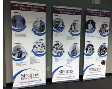
Stearns History Museum wrote the biographies of 25 identified women from Stearns County who have made a direct contribution to the history of sports and the passage and implementation of Title IX Education Amendments on June 23, 1972. The project addresses how the women's experiences influenced their lives and careers beyond athletics.
Source Water Protection is one of the three priority concerns identified in the Stearns Comprehensive Local Water Managment Plan. Currently, Stearns County has 23 public water supplies with approved Wellhead Protection Plans. This encompasses approximately 65,000 acres of land in Drinking Water Supply Management Areas (DWSMA). This proposal will fund at least 10 unused well sealing projects within these sensitive areas.
The Stearns County Soil and Water Conservation District's (SWCD) Stump and Sagatagan Lakes Subwatershed Stormwater Treatment Projects will retrofit sub-catchment drainage areas on St. John's University (SJU) campus that drain untreated stormwater runoff directly into Stump and Sagatagan Lakes. This area of the region has been identified as ecologically significant by the Nature Conservancy's Eco-Regional Plan and the MN DNR's County Biological Survey.
Stearns County Ditch 26 (CD 26) is a 20 mile channelized section of Getchell Creek, a primary tributary to the Sauk River that is impaired for turbidity, E.coli and aquatic macroinvertebrate bio-assessment. The Stearns County Ditch 26 Drainage Management Project will address the stormwater runoff concerns identified within this public drainage system. Alternative intake structures to manage nutrients and mitigative measures will be taken to retain water on the upland properties and minimize flow rate and velocity.
The Children's Discovery Museum's (CDM) new 3,000 piece Wizard of Oz (WOZ) collection will be properly archived, conservation materials purchased, and exhibit concept and design drawings completed. CDM facilitators and educators will travel to other children's museums in Minnesota for staff enrichment and professional development.
This project seeks to provide data on insecticide contamination in the soil and the insect community across the state and the effect of sublethal insecticide exposure on insect reproduction.
To support teachers in addressing new science standards , we propose a series of workshops across Minnesota facilitating conversation about sustainability and water conservation, specifically integrating western science and Indigenous perspectives.
Central MN Community Empowerment Organization will revitalize the use of cultural and artistic expressions for the Somali youth of Minnesota to preserve and display their cultural heritage. CMCEO plans to promote patriotism and citizenship through cultural heritage where artists are trained to compose Somali creative arts and music. This will enable youth to learn their cultural heritage and creativity in an engaging environment.
This project involves monitoring three data deficient lakes in the Crow Wing River Watershed and one stream site at the inlet to White Earth Lake. The data deficient lakes were on the MPCA Targeted watershed list. After getting the required assessment dataset for these lakes, all targeted lakes in Becker County will be completed for this assessment cycle. The stream site is a site that the White Earth Lake Association and the Becker Coalition of Lake Associations (COLA) will monitor. It is the inlet to White Earth Lake.
This project will include stream monitoring of six preselected sites from the Leech Lake Watershed (HUC 07010102) and Pine River Watershed (HUC 07010105). The sites will be monitored for chemical, physical and biological parameters for two years.
This project will collect water quality data for 13 Hubbard County lakes located in the Crow Wing priority watershed and identified as priority lakes by the MPCA. Upon completion the project data set will include all of the necessary information for the lakes to be assessed for impairment due to nutrients. Volunteers will collect samples from 7 of the 13 lakes and paid SWCD staff will collect samples from 6 of the lakes that do not have public access or volunteers willing to sample. The water samples will be collected 5 times/year June-September in 2010 and 2011.
The Crow Wing County (CWC) Water Plan identifies Island-Loon Lake as a priority lake to enhance due to its significant decline in water clarity and high ratio of impervious surface surrounding the lake. To mitigate the runoff, the Crow Wing Soil and Water Conservation District will partner with the CWC HWY Department, City of Crosslake, Crosslakers, and Whitefish Area Property Owners Association to install three mechanical separators and 13,500 square feet bioretention area that will reduce six pounds of phosphorus and 1 ton of sediment per year from entering the lake.
The Crow Wing Soil and Water Conservation District partnered with Cass SWCD, Hubbard SWCD, and the Board of Water and Soil Resources to permanently protect 239.6 acres of upland forest land, wetlands, and shorelines to develop larger habitat blocks. We worked with seven landowners in total to complete seven RIM easements - acres by county Cass: 117 acres, Crow Wing 34 acres, and Hubbard 87 acres. Partners met regularly; the regional committee completed the final application recommendations to move forward into the RIM easement process.
RESPEC is a contractor with knowledge of site-specific standard development and will respond to United States Environmental Protection Agency questions and concerns regarding attainability of standards. The response will be based on bathtub model data and also a review of technical memorandums developed by the Minnesota Pollution Control Agency on aquatic life and aquatic recreational standard attainability.
A new GIS technician will help prioritize and target conservation activities and protection strategies in nine north-central Minnesota counties. The GIS technician will create GIS products, assessments, and watershed analysis to identify the high priority areas in each County or watershed in need of protection or restoration using all available data, including LiDAR, soils, land use, completed WRAPS and other datasets. These areas will then be targeted for future resource management efforts, Clean Water Fund projects, and additional conservation activities.
The Sauk River watershed was selected to participate in the federal Mississippi River Basin Initiative (MRBI) program in 2010 to decrease nutrient contributions to the Mississippi River and the Gulf of Mexico. The MRBI program provides federal cost share funds to landowners to install conservation practices.
The Children's Discovery Museum in Grand Rapids, Minnesota will increase access and deepen engagement with their effectively proven School Service Program. The museum will take down the economic barriers and increase enrollment. This grant will fund more educators and facilitators, curriculum development, scholarship aid, transportation assistance and art/teaching supplies.
Fourteen permanent RIM Easements on 766 acres of high quality, riparian and forested habitat have been recorded and will provide lasting wildlife habitat. Attempts were made to acquire three tracts in fee title that would have relied on this funding. The owner of one tract rejected an offer of the certified appraised value. Acquisition attempts on the other two tracts were discontinued when it became apparent that the planned use of the land as DNR Wildlife Management Area would be incompatible with local government plans for future municipal growth.
Thiel Creek is a designated trout stream in southern Stearns County and outlets into Lake Marie and Lake Louisa. Both lakes are impaired for nutrients. Thiel Creek is experiencing severe bank erosion and local residents have expressed concern about the excessive sedimentation entering the lakes. Most of this erosion is occurring on an approximate mile reach of the creek just upstream of the outlet into the lake.
The goal of this project is to conduct water quality monitoring at the ten lakes within the Todd County portions of the Mississippi River Brainerd and the one lake within the Todd County portion of the Mississippi River Sartell. Sampling will be done once per month between May 2016 and September 2016 and then again once per month May 2017 through September 2017.
Saint Cloud is deeply divided by race and radicalized violence. The Saint Cloud library is perceived as the only true commons space where all people can feel welcomed and safe. This incident has brought up trauma amongst staff and the community, especially people of Somali and eastern African heritage. This project includes partnering with the Rainbow Wellness Collective, to offer five, 2-hour art making sessions, focused on creative writing, painting, collage-making, lyrical dancing, and drumming circles, at the library.
This project will build off the success of the additional geographic information system (GIS) and water planning expertise the TSA8 added in 2016 to provide consistent mapping, water planning assistance and training to partners. This project will help soil and water conservation districts prepare for the 1W1P process before the planning starts. A unified protection methodology is essential for the 1W1P process to be successful. This project will include: unified GIS mapping and protection model for all nine counties respectively.
 Stearns History Museum wrote the biographies of 25 identified women from Stearns County who have made a direct contribution to the history of sports and the passage and implementation of Title IX Education Amendments on June 23, 1972. The project addresses how the women's experiences influenced their lives and careers beyond athletics.


