Phase 5 of the Sate Forest Acquisition project protected 43 acres of critical forest habitat in the southeastern ecological section of the state. These lands have been incorporated into the State Forest program of the Outdoor Recreation System, and will be sustainably managed for quality wildlife habitat, timber production, and public recreation in perpetuity. Additionally, over 300 acres of sensitive floodplain forest habitat were enhanced using a variety of methods.
Protected through fee title acquisition 340 acres of priority forestland habitat in the northern and southeast ecological sections of the state. All parcels have been included in the DNR State Forest system; providing for long-term, ongoing protection and management of lands for the benefit of all Minnesotans.
MNHS and the Minnesota State Fair Foundation increased awareness and knowledge of Minnesota history by providing quality programming for visitors to the Great Minnesota Get-Together. In 2016, new content was added to the Minnesota State Fair History Walking Tour brochure, including a wide array of diverse images of people at the fair. Audio and visual content was also available through the tour's smartphone component, and staff presented audio/visual content via social media throughout the fair.
This agreement is for Board of Water and Soil Resources (BWSR) to provide statewide conservation reporting system support services in order to support Minnesota Pollution Control Agency (MPCA) programs. Support services will be aimed at both MPCA staff and local government recipients of grants.
The Statewide Sediment Network was established to measure the levels of suspended sediment concentrations and particle size distributions at eight sites across Minnesota to evaluate the amount of sediment carried by rivers. USGS sample collection and laboratory analysis techniques provide a more rigorous, robust, and technically accurate measure of sediment in water than the current use of total suspended solids as the measure of sediment in water.
Nitrate-nitrogen (nitrate) is one of the contaminants of greatest concern for groundwater in Minnesota. This funding is being used for activities that help identify the severity and magnitude of nitrate contamination and implement practices at the local level to reduce nitrate in groundwater. The Minnesota Department of Agriculture (MDA) is working with many local partners and passing funding through to local government units (counties, cities, soil and water conservation districts) to address this concern.
The MDA's technical assistance helps ensure that current and accurate scientific information is made available and used to address water quality concerns in agricultural areas of Minnesota. This funding has been used to evaluate the effectiveness of conservation practices, share information from research and demonstration sites and enhance outreach and education to the agricultural community and local government partners.
The goal of this project will be to research and develop statewide winter maintenance best management practices (BMPs) for inclusion in the Statewide Chloride Management Plan and Winter Maintenance Assessment tool (WMAt). The WMAt is a necessary technical resource and planning tool for stakeholders and permittees to implement the chloride reduction strategies described in the Statewide Chloride Management Plan. This project will enhance the WMAt so that it is an effective planning tool to assist local winter maintenance professionals to reduce salt use.
The goal of this project is to update and revise the Twin Cities Metro Area (TCMA) Chloride Management Plan to a Statewide Chloride Management Plan (CMP). The Statewide CMP will provide stakeholders the information and tools necessary to improve and/or maintain water quality with respect to chloride.
The Legislature created the Statewide Survey of Historic & Archaeological Sites to provide opportunities to expand our understanding of historic and archaeological sites statewide.
Projects are defined by an oversight board and are conducted through competitive-bid contracts.
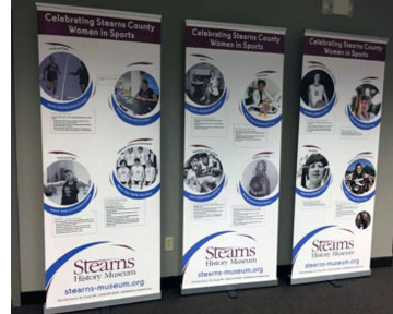
Stearns History Museum wrote the biographies of 25 identified women from Stearns County who have made a direct contribution to the history of sports and the passage and implementation of Title IX Education Amendments on June 23, 1972. The project addresses how the women's experiences influenced their lives and careers beyond athletics.
Source Water Protection is one of the three priority concerns identified in the Stearns Comprehensive Local Water Managment Plan. Currently, Stearns County has 23 public water supplies with approved Wellhead Protection Plans. This encompasses approximately 65,000 acres of land in Drinking Water Supply Management Areas (DWSMA). This proposal will fund at least 10 unused well sealing projects within these sensitive areas.
This grant seeks to build the top 5 prioritized projects (2 iron-enhanced sand filters, 1 rain garden, 1 infiltration trench, and 1 tree trench) within the City of New London. Installation of these project will result in a cost-effective pollutant reduction from city runoff to various nearby water resources. The project is estimated to reduce sediment by 2 tons and phosphorus by 8 pounds annually.
In partnership with Metro Blooms, the Mississippi Watershed Management Organization (MWMO) will implement stormwater Best Management Practices (BMPs) at a minimum of six properties along commercial nodes targeted for re-investment by the City of Minneapolis' Business District Support program.
Stream flow information is essential for understanding the state of Minnesota's waters. Clean water funding has allowed the DNR to expand a network of stream gages that support planning and implementation for clean water protection and restoration. These gages are also used as part of the interagency Flood Forecasting/Warning System. This expanded stream gaging network has also significantly increased the real time data available to recreational water enthusiasts via the internet.
This project will provide information and tools for a method to credit street sweeping that can be implemented by Municipal Separate Storm Sewer (MS4) permittees to help meet permit requirements for phosphorus and total suspended solids (TSS). The contractor will develop and submit a communication-outreach plan for the credit method.
The Ramsey Conservation District is partnering with the Vadnais Lake Area Water Management Organization, St. Paul Regional Water Service, and Ramsey County Parks and Recreation to restore and stabilize approximately 550 linear feet of streambank along the Sucker Lake Channel in northeastern Ramsey County with a cost effective critical area planting, replacing the existing mix of turf grass and asphalt streambank with a native vegetation planting.
The project will work with county and Waseca Soil and Water Conservation District staff to increase knowledge and participation in the Watershed Approach efforts and provide input to the Watershed Restoration and Protection Strategies (WRAPS) document.
MNHS continues to strive for environmental, economic and social sustainability in its sustainability program. To pinpoint opportunities for ongoing progress, the sustainability program will harmonize a broader range of institutional needs and objectives. The program will establish integrated, continuous, electronic reporting that unites environmental, social and economic risk analysis. This reporting will be used to further reduce our environmental impact and improve the sustainability of our operations as a whole.
Swedish Immigrant Regional Trail connection through Interstate Park to Taylors Falls City Hall. Build 180 bridge and trail segment A&B as illustrated. Segment C reviews and engineering only.
Swift Soil and Water Conservation District plans on monitoring seven stream sites of the Chippewa River Watershed within Swift county. Through this process we hope to assist the Minnesota Pollution Control Agency (MPCA) in identifying sites in this study area that are either improving or degrading in water quality.
The Crow Wing County (CWC) Water Plan identifies Island-Loon Lake as a priority lake to enhance due to its significant decline in water clarity and high ratio of impervious surface surrounding the lake. To mitigate the runoff, the Crow Wing Soil and Water Conservation District will partner with the CWC HWY Department, City of Crosslake, Crosslakers, and Whitefish Area Property Owners Association to install three mechanical separators and 13,500 square feet bioretention area that will reduce six pounds of phosphorus and 1 ton of sediment per year from entering the lake.
This project will educate and also encourage residents to join the Le Sueur County cost-share well sealing program to provide assistance in sealing unused/abandoned wells.
With the proposed project, the Pomme de Terre River Association will target catchments delivering the highest 25% of sediment from agricultural land and identified priority management zones for storm water runoff (identified in the Watershed Restoration and Protection Strategy). Implementation is estimate to reduce sediment runoff to prioritized water bodies by 14,690 tons per year and phosphorous by 12,270 pounds per year.
The LeSueur River Watershed is one of the highest nutrient loading watersheds for both phosphorus and nitrogen in the State of Minnesota. The LeSueur River Watershed Restoration and Protection Strategies (WRAPS) Report was completed in August 2015 and further identifies pollutant sources and reduction goals within the LeSueur River Watershed. The WRAPS report highlights the Beauford Ditch watershed and the Madison Lake watershed area amongst the highest sources of nutrient loading to the LeSueur River.


 Stearns History Museum wrote the biographies of 25 identified women from Stearns County who have made a direct contribution to the history of sports and the passage and implementation of Title IX Education Amendments on June 23, 1972. The project addresses how the women's experiences influenced their lives and careers beyond athletics.


