Having current and accurate data on historic and archaeological sites is important to understanding our past and to preserving Minnesota’s history for future generations. In 2010-2011, the Minnesota Historical Society awarded contracts for these survey projects:
Replace campfire rings in state parks and state recreation areas with accessible campfire rings. New fire rings have been purchased for 36 (47%) of all state park and recreation areas.
Minnesota's Scientific and Natural Area (SNA) Program is an effort to preserve and perpetuate the state's ecological diversity and ensure that no single rare feature is lost from any region of the state. This includes unique landforms, fossil remains, plant and animal communities, rare and endangered species, or other unique biotic or geological features. These sites play an important role in scientific study, public education, and outdoor recreation.
Nitrate-nitrogen (nitrate) is one of the contaminants of greatest concern for groundwater in Minnesota. This funding is being used for activities that help identify the severity and magnitude of nitrate contamination and implement practices at the local level to reduce nitrate in groundwater. The Minnesota Department of Agriculture (MDA) is working with many local partners and passing funding through to local government units (counties, cities, soil and water conservation districts) to address this concern.
The MDA's technical assistance helps ensure that current and accurate scientific information is made available and used to address water quality concerns in agricultural areas of Minnesota. This funding has been used to evaluate the effectiveness of conservation practices, share information from research and demonstration sites and enhance outreach and education to the agricultural community and local government partners.
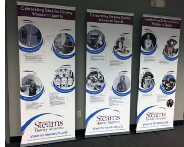
Stearns History Museum wrote the biographies of 25 identified women from Stearns County who have made a direct contribution to the history of sports and the passage and implementation of Title IX Education Amendments on June 23, 1972. The project addresses how the women's experiences influenced their lives and careers beyond athletics.
Source Water Protection is one of the three priority concerns identified in the Stearns Comprehensive Local Water Managment Plan. Currently, Stearns County has 23 public water supplies with approved Wellhead Protection Plans. This encompasses approximately 65,000 acres of land in Drinking Water Supply Management Areas (DWSMA). This proposal will fund at least 10 unused well sealing projects within these sensitive areas.
This project will establish up to 12 miles of riparian buffers along the Pomme de Terre River and its tributaries and install up to 5 raingarden within the cities of Morris and Chokio as identified in the Pomme de Terre TMDL Implementation Plan.
In recent times, the owners of Wolf Marine on the St. Croix River have to excavate sediment that has built up at the outlet of Brown's Creek every year just to keep their marina navigable. Their business is directly affected by how much soil gets into the creek. Reducing dirt and sand entering Brown's Creek is also important to others. The creek is one of the few designated trout streams in the Twin Cities area that supports a fishable brown trout population.
Partner Organizations: Anoka County Historical Society, Hennepin History Museum.
Suburbanization has reached nearly all corners of Hennepin and Anoka Counties. The two counties are bound together by the state's largest school district: Anoka-Hennepin. Working together, the Anoka and Hennepin County Historical Societies are gathering resources located in numerous repositories so that they, and future historians, will have a logical starting place from which to draw information about the suburbanization of Anoka and Hennepin counties.
This grant seeks to build the top 5 prioritized projects (2 iron-enhanced sand filters, 1 rain garden, 1 infiltration trench, and 1 tree trench) within the City of New London. Installation of these project will result in a cost-effective pollutant reduction from city runoff to various nearby water resources. The project is estimated to reduce sediment by 2 tons and phosphorus by 8 pounds annually.
Through the Stormwater Retrofit Partnership, the Dakota Soil and Water Conservation District (DSWCD) provides the funding and technical assistance to prioritize and install Best Management Practices (BMPs) at existing public facilities. This project is needed because, like other urban properties that developed before stormwater regulations, most government owned facilities were designed and constructed without optimal water quality features.
Stream flow information is essential for understanding the state of Minnesota's waters. Clean water funding has allowed the DNR to expand a network of stream gages that support planning and implementation for clean water protection and restoration. These gages are also used as part of the interagency Flood Forecasting/Warning System. This expanded stream gaging network has also significantly increased the real time data available to recreational water enthusiasts via the internet.
This project will provide information and tools for a method to credit street sweeping that can be implemented by Municipal Separate Storm Sewer (MS4) permittees to help meet permit requirements for phosphorus and total suspended solids (TSS). The contractor will develop and submit a communication-outreach plan for the credit method.
Grants to counties to implement SSTS programs including inventories, enforcement, development of databases, and systems to insure SSTS maintenance and of reporting program results to BWSR and MPCA and base grants.
The project will work with county and Waseca Soil and Water Conservation District staff to increase knowledge and participation in the Watershed Approach efforts and provide input to the Watershed Restoration and Protection Strategies (WRAPS) document.
The Society sought out potential grant applicants, led grant-writing workshops, presented at 43 public meetings statewide and conducted onsite visits in approximately 40 communities.
This project will assess lakes and streams in the Cannon River watershed that have not been assessed to determine if they are meeting their designated uses. Some of these lakes and streams have data for certain pollutants, but not enough to complete an impairment assessment. The river and stream reaches are located in Dakota, Goodhue, Le Sueur, Rice, Steele, and Waseca counties. The lakes are located throughout the Cannon watershed (Le Sueur, Rice and Waseca Counties). This project will be a continuation of past assessments conducted in 2007 and 2009.
This project will collect water chemistry and field parameters at the Popple River, Bowstring River, Big Fork River, Rice River, Caribou Lake and Eagle lake. It will also support the biological assessments being completed by MPCA staff for this Target Watershed Assessment. This project is a collaborative effort with MPCA, 3 SWCDs, and the well established Bigfork River Watch Program. This project is a collaborative effort with Lake of the Woods and Koochiching County SWCDs because the Big Fork Watershed encompasses both Itasca and Koochiching Counties.
The St. Louis River Alliance will complete the data set for the water quality assessment of six target streams in the Lake Superior Basin. These streams are the Gooseberry River, Beaver River, Lester River, Big Sucker River, Split Rock River and Knife River. In addition, the St. Louis River Alliance will complete the data set for the water quality assessment of two non-target streams in the St. Louis River watershed. These two streams are Coffee Creek and Buckingham Creek. The St.
The Nobles Soil and Water Conservation District (SWCD) will test waters needing data for impairment listing in the Rock River and Little Sioux watersheds. Two reaches of the Little Rock River and the Ocheyedan River need stream water assessments. Iowa Lake needs sampling completed for impairment identification. The project will obtain adequate stream and lake data to either list the tested stream reaches and lake on the 303(d) list as impaired, or provide evidence that the stream reaches and lake is not impaired.
This assessment will be performed using scientific volunteers, will build capacity at a technical training program at Itasca Community College (ICC), and will provide MPCA with answers providing a reasonable expectation for water quality in this under-studied region of Minnesota.
This project involves monitoring three data deficient lakes in the Crow Wing River Watershed and one stream site at the inlet to White Earth Lake. The data deficient lakes were on the MPCA Targeted watershed list. After getting the required assessment dataset for these lakes, all targeted lakes in Becker County will be completed for this assessment cycle. The stream site is a site that the White Earth Lake Association and the Becker Coalition of Lake Associations (COLA) will monitor. It is the inlet to White Earth Lake.
This project will obtain lab and field data for waterbodies within the Wild Rice Watershed, to meet surface water assessment goals. Data will continue to be collected further upstream of some 2008 sites and enhance current assessment datasets. Some new tributaries, that lack assessment data, will also be monitored. The project goal is to complete the datasets necessary for the assessment of Aquatic Recreation Use for twelve streams in the Wild Rice Watershed.


 Stearns History Museum wrote the biographies of 25 identified women from Stearns County who have made a direct contribution to the history of sports and the passage and implementation of Title IX Education Amendments on June 23, 1972. The project addresses how the women's experiences influenced their lives and careers beyond athletics.


