Project Overview Minnesota, which was recently named "Best Trails State" in the country, is host to numerous state trails providing a variety of different outdoor recreational opportunities throughout the state. This appropriation is allowing the Minnesota Department of Natural Resources to acquire land expanding two of these state trails: the Brown's Creek segment of the Willard Munger Trail in Washington County and the Paul Bunyan Trail along Lake Bemidji.
Having current and accurate data on historic and archaeological sites is important to understanding our past and to preserving Minnesota’s history for future generations. In 2010-2011, the Minnesota Historical Society awarded contracts for these survey projects:
Each fiscal year of ACHF funding, a majority of the twelve regional library systems agree to allocate 10% of their ACHF funding to support statewide partnership projects. SELCO serves as the fiscal agent for statewide projects.
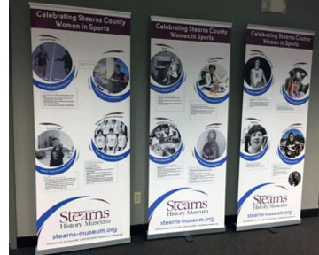
Stearns History Museum wrote the biographies of 25 identified women from Stearns County who have made a direct contribution to the history of sports and the passage and implementation of Title IX Education Amendments on June 23, 1972. The project addresses how the women's experiences influenced their lives and careers beyond athletics.
Source Water Protection is one of the three priority concerns identified in the Stearns Comprehensive Local Water Managment Plan. Currently, Stearns County has 23 public water supplies with approved Wellhead Protection Plans. This encompasses approximately 65,000 acres of land in Drinking Water Supply Management Areas (DWSMA). This proposal will fund at least 10 unused well sealing projects within these sensitive areas.
The Stearns County Soil and Water Conservation District's (SWCD) Stump and Sagatagan Lakes Subwatershed Stormwater Treatment Projects will retrofit sub-catchment drainage areas on St. John's University (SJU) campus that drain untreated stormwater runoff directly into Stump and Sagatagan Lakes. This area of the region has been identified as ecologically significant by the Nature Conservancy's Eco-Regional Plan and the MN DNR's County Biological Survey.
Stearns County Ditch 26 (CD 26) is a 20 mile channelized section of Getchell Creek, a primary tributary to the Sauk River that is impaired for turbidity, E.coli and aquatic macroinvertebrate bio-assessment. The Stearns County Ditch 26 Drainage Management Project will address the stormwater runoff concerns identified within this public drainage system. Alternative intake structures to manage nutrients and mitigative measures will be taken to retain water on the upland properties and minimize flow rate and velocity.
A consultant was hired to facilitate a process to grow the capacity of the organization to preserve and interpret history through a national training standard, known as StEPs. The StEPs program is an on-going process for continuous improvement.
To grow the capacity of the organization to preserve and interpret history through a national training standard, the Firefighter's Hall and Museum completed four of six areas of the StEPs Program at the Bronze level. The areas completed were the Mission, Values and Governance, Management, Audience and Interpretation sections. The FHM does not have historic structures or landscapes so that area does not apply. The Collections area was too large to complete before the June deadline. The Museum plans to continue the StEPs work and the collections project is a top priority.
Partner Organizations: Anoka County Historical Society, Hennepin History Museum.
Suburbanization has reached nearly all corners of Hennepin and Anoka Counties. The two counties are bound together by the state's largest school district: Anoka-Hennepin. Working together, the Anoka and Hennepin County Historical Societies are gathering resources located in numerous repositories so that they, and future historians, will have a logical starting place from which to draw information about the suburbanization of Anoka and Hennepin counties.
In partnership with Metro Blooms, the Mississippi Watershed Management Organization (MWMO) will implement stormwater Best Management Practices (BMPs) at a minimum of six properties along commercial nodes targeted for re-investment by the City of Minneapolis' Business District Support program.
The Children's Discovery Museum's (CDM) new 3,000 piece Wizard of Oz (WOZ) collection will be properly archived, conservation materials purchased, and exhibit concept and design drawings completed. CDM facilitators and educators will travel to other children's museums in Minnesota for staff enrichment and professional development.
To hire a qualified engineer to conduct a structural assessment of the 1887 Alano Society of Minneapolis Clubhouse (John Washburn House), listed in the National Register of Historic Places.
Stubbs Bay on Lake Minnetonka is impaired for excess nutrients due to phosphorus loading. This impairment results in nuisance algae blooms that limit the recreational use of this water body. As a part of its surface water management planning process, the City of Orono has identified projects to help improve the water quality of Stubbs Bay and Lake Minnetonka. The Stubbs Bay Ravine Stabilization project is one of the projects scheduled for completion in 2011.
Grants to counties to implement SSTS programs including inventories, enforcement, development of databases, and systems to insure SSTS maintenance and of reporting program results to BWSR and MPCA and base grants.
The Upper Minnesota River Water Quality Assessment Project will complete water chemistry assessments of the upper reaches of the Minnesota River Headwaters, which includes the main stem of the river, five main tributaries (Meadowbrook Creek, Salmonsen Creek, Fish Creek, Hoss Creek, Little Minnesota River and Stoney Run Creek), and one flowage lake (Long Tom).
This project involves monitoring three data deficient lakes in the Crow Wing River Watershed and one stream site at the inlet to White Earth Lake. The data deficient lakes were on the MPCA Targeted watershed list. After getting the required assessment dataset for these lakes, all targeted lakes in Becker County will be completed for this assessment cycle. The stream site is a site that the White Earth Lake Association and the Becker Coalition of Lake Associations (COLA) will monitor. It is the inlet to White Earth Lake.
The Pioneer-Sarah Creek Watershed Assessment project will complete a condition assessment for all currently unassessed or partially assessed (i.e., incomplete datasets) lakes and streams throughout the Pioneer-Sarah Creek (PSC) watershed (South Fork of Crow River; Hennepin County).
This project will include stream monitoring of six preselected sites from the Leech Lake Watershed (HUC 07010102) and Pine River Watershed (HUC 07010105). The sites will be monitored for chemical, physical and biological parameters for two years.
This project will collect additional water quality and flow data on tributaries on the South Fork Crow River and Buffalo Creek. Further assessment of these reaches will provide a better understanding of what impacts these tributaries have on the impaired South Fork Crow River and Buffalo Creek.
This project will collect water quality data for 13 Hubbard County lakes located in the Crow Wing priority watershed and identified as priority lakes by the MPCA. Upon completion the project data set will include all of the necessary information for the lakes to be assessed for impairment due to nutrients. Volunteers will collect samples from 7 of the 13 lakes and paid SWCD staff will collect samples from 6 of the lakes that do not have public access or volunteers willing to sample. The water samples will be collected 5 times/year June-September in 2010 and 2011.
Swift Soil and Water Conservation District plans on monitoring seven stream sites of the Chippewa River Watershed within Swift county. Through this process we hope to assist the Minnesota Pollution Control Agency (MPCA) in identifying sites in this study area that are either improving or degrading in water quality.
Hubbard, Crow Wing, and Cass County Land Departments and Soil and Water Conservation Districts (SWCD) will partner to acquire 300 acres (public access) and place easements on 240 acres of private high-quality forest, wetlands, and shoreline in the Northern Forest Ecological Section. This project is integrating county land management goals and parcel selection into the 75 percent protection watershed goal (Phase 1 Watershed Grant).
With the proposed project, the Pomme de Terre River Association will target catchments delivering the highest 25% of sediment from agricultural land and identified priority management zones for storm water runoff (identified in the Watershed Restoration and Protection Strategy). Implementation is estimate to reduce sediment runoff to prioritized water bodies by 14,690 tons per year and phosphorous by 12,270 pounds per year.
The objective of the project is to develop a targeted stormwater implementation and outreach program focused on non-profit partners. The Nine Mile Creek Watershed District is a 50 square mile fully-developed watershed with 15 major lakes and over twenty miles of creek system. Given that much development in this area occurred prior to the era of stormwater management regulations, runoff from many sites is untreated prior to discharge to downstream water bodies.


 Stearns History Museum wrote the biographies of 25 identified women from Stearns County who have made a direct contribution to the history of sports and the passage and implementation of Title IX Education Amendments on June 23, 1972. The project addresses how the women's experiences influenced their lives and careers beyond athletics.