Under the CREP partnership with USDA, 38 easements were recorded on a total of 2,732 acres to restore previously drained wetlands and adjacent uplands. One easement is a flowage easement that was required to complete wetland restoration work on an adjacent
The Clean Water Fund (CWF) and Outdoor Heritage Fund (OHF) were used together to secure easements on buffer areas. 84 easements have been recorded for a total of 1,441 acres and are reported in the output tables for the final report (acre total does not include Clean Water Fund acres). The total acreage from both CWF and OHF sources for recorded easements is 2,793.2 acres. Only the OHF acres are being reported in this final report to be consistent with the approved accomplishment plan.
Using the Reinvest in Minnesota (RIM) program, this project addresses the potential loss of grassland habitats from conversion to cropland and accelerates grassland protection efforts not covered by other programs. Working in coordination with 11 established Prairie Conservation Plan Local Technical Teams (LTTs), and local SWCDs this proposal will enroll 936 RIM acres (approximately 12 easements), focusing on Minnesota Prairie Plan identified landscapes.
RIM Wetlands - Restoring the most productive habitat in Minnesota's Prairie Pothole Region will protect and restore approximately 520 acres of previously drained wetlands and adjacent native grasslands on approximately 12 easements across the State. The Board of Water and Soil Resources (BWSR) will utilize the Reinvest in Minnesota (RIM) easement program in partnership with local Soil and Water Conservation District (SWCDs) to target, protect and restore high priority habitat. The program will utilize a ranking and selection process and be implemented locally by SWCD staff.
This program is a part of a comprehensive clean water strategy to prevent sediment and nutrients from entering our lakes, rivers, and streams; enhance fish and wildlife habitat; protect groundwater and wetlands. Specifically the Riparian Buffer Easement Program targets creating buffers on riparian lands adjacent to public waters, except wetlands. Through the Reinvest in Minnesota Program (RIM) and in partnership with Soil and Water Conservation Districts and private landowners, permanent conservation easements are purchased and buffers established.
We propose identifying hot spots of groundwater chloride pollution of surface waters due to excessive road salt use, which is a long term source increasing chloride impairment of surface waters.
Scientific and Natural Area (SNA) strategic acquisition (~85 acres) will conserve Minnesota's most unique places and rare species for everyone's benefit.
Approximately 70 percent of all Minnesotans rely on groundwater as their primary source of drinking water. Wells used for drinking water must be properly sealed when removed from service to protect both public health and Minnesota’s invaluable groundwater resources. The Minnesota Department of Health protects both public health and groundwater by assuring the proper sealing of unused wells.
Clean Water funds are being provided to well owners as a 50% cost-share assistance for sealing unused public water-supply wells.
This education project will continue building the next generation of conservationists in Minnesota by engaging youths and adults in science and outdoor learning through radio, podcasts, newsletters and schoolyard exploration.
The goal of this project is the continued development of an overall strategy for reduction of turbidity/TSS, with sets of sediment reduction initiatives and actions for various sources, to address the Minnesota River Turbidity TMDL and the South Metro Mississippi River TSS TMDL. The overall strategy will be used to help establish a path towards achieving the required reductions of turbidity/TSS.
The Seven Mile Creek Condition Monitoring project will maintain and build on the continuous flow and water quality data base at three stream sites and one county tile in the Seven Mile Creek watershed through the collection of approximately eighty five water samples per monitoring season in preparation for the Middle Minnesota Intensive Watershed Monitoring scheduled to begin in 2013.
Funding through this appropriation enhanced 4,745 acres of wetland habitat. Four wetland/shallow lake infrastructure projects were competed that enhanced 1,020 acres and and another project restored 50 acres. Wetland management actions (wild rice seeding, a significant drawdown, and a major large prescribed burn) enhanced 1,997 acres. Work by the Region 3 Roving Habitat Crew enhanced 1,678 wetland acres through work on prescribed burns, drawdowns, herbicide applications, and removal of woody vegetation.
State leadership for the 4-H Shooting Sports & Wildlife Program, including staff and 4-H volunteer committee members, will provide a menu of equipment options for local programs to choose from as a means to build their Shooting Sports & Wildlife project. Local programs will submit a grant application justifying how the new equipment will help them build and grow their program, attract and engage new audiences, and provide sustainability in their local chapter.
The Greater Blue Earth River Basin is a large area within the Watonwan, Le Sueur, and Blue Earth River watersheds. Recent research by University of Minnesota, the National Center for Earth Dynamics, and others has found this basin to be the largest contributor of sediment to Lake Pepin.
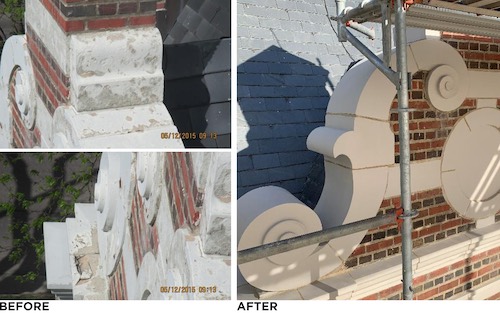
The Brown County Museum has been located in the former New Ulm Post Office building since 1985.The historic building in New Ulm, Minnesota, United States was built in 1909 and was placed on the National Register of Historic P
Each fiscal year of ACHF funding, a majority of the twelve regional library systems agree to allocate 10% of their ACHF funding to support statewide partnership projects. SELCO serves as the fiscal agent for statewide projects.


 The Brown County Museum has been located in the former New Ulm Post Office building since 1985.The historic building in New Ulm, Minnesota, United States was built in 1909 and was placed on the National Register of Historic P